Articles / LORQAI
The Islands That Float on Water
Discover how Loktak Lake’s floating islands form, why the rare sangai deer depends on them, and how changing water levels threaten this Indian wetland.
Introduction
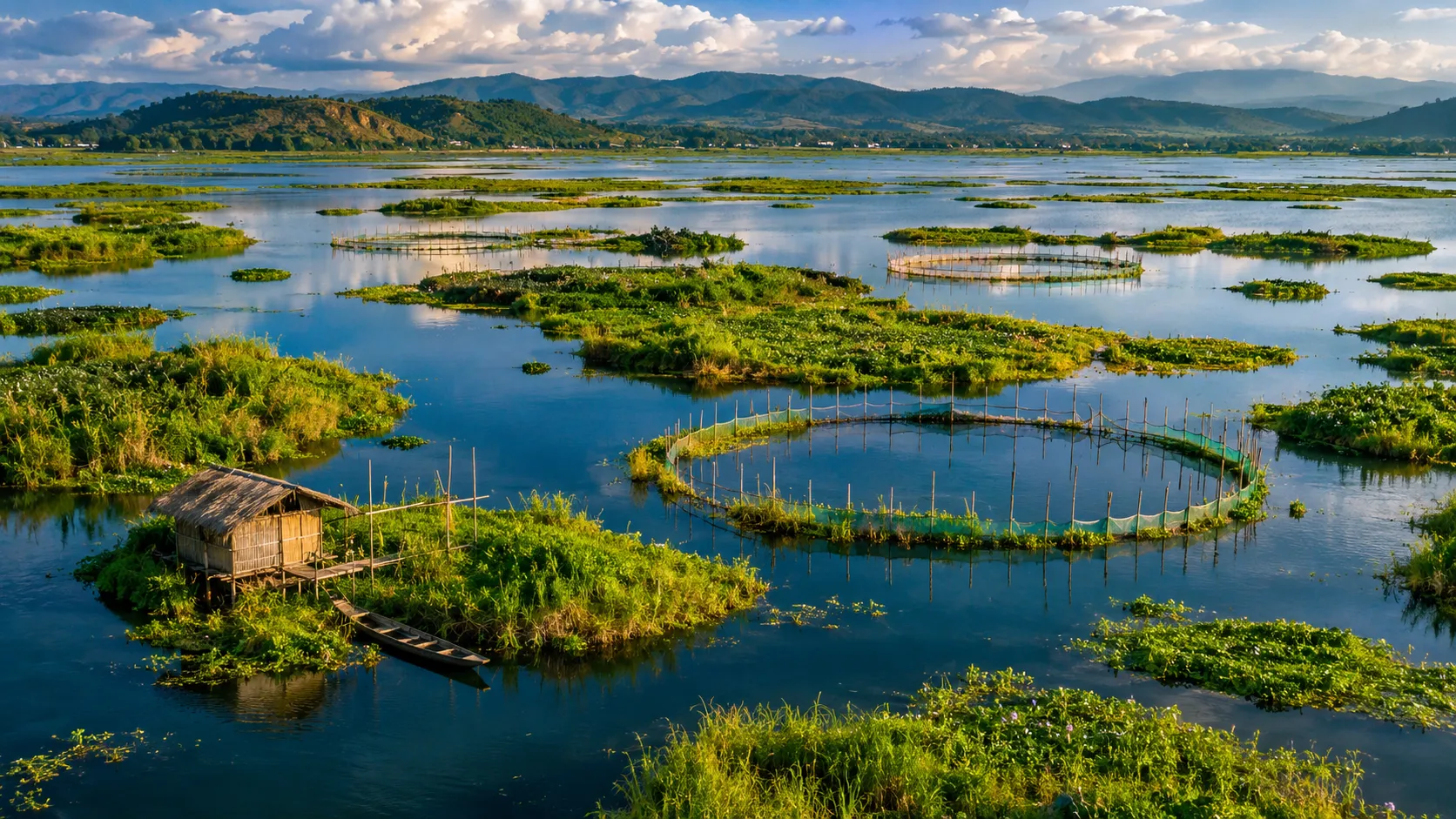
Imagine looking down from a hillside onto a vast freshwater lake.
Across the blue surface are hundreds of green shapes.
Some are long and irregular. Others look like small islands. Many form circles and curved lines that resemble enormous patterns drawn onto the water.
From a distance, the lake seems to contain pieces of land that have somehow broken away from the shore.
But these are not ordinary islands.
Many are floating masses of vegetation, soil, and decomposing organic matter.
They can shift with the water, change shape, grow, and gradually break apart.
In one part of the lake, the floating vegetation forms an extraordinary habitat large enough to support a population of rare deer.
This is Loktak Lake, in Manipur, northeastern India.
Its floating landscapes are known as phumdis.
And their existence challenges a familiar assumption about the difference between land and water.
We usually think of an island as a fixed piece of solid ground surrounded by water.
At Loktak, the boundary is not so simple.
A Lake Where the Land Can Move
Loktak is the largest natural freshwater lake in northeastern India.
It lies within the Manipur valley, receiving water from rivers, streams, rainfall, and the surrounding catchment.
Its size and appearance have changed over time as water levels, sedimentation, vegetation, and human activity have altered the wetland.
The Loktak Development Authority describes a water body covering approximately 287 square kilometers under its managed water-level conditions.
The Ramsar Convention records a designated wetland area of 26,600 hectares, or 266 square kilometers.
These figures describe different administrative or hydrological measurements and should not be treated as permanent, interchangeable boundaries.
Water levels and vegetation cover influence how much open water appears at any particular time.
But the lake's most recognizable feature is not its size.
It is the presence of floating vegetation.
Large parts of Loktak contain dense mats made of grasses, reeds, roots, soil particles, and organic material in different stages of decomposition.
The mats vary considerably.
Some are relatively thin and fragmented.
Others are substantial enough to support extensive vegetation.
In the southern part of the lake, the floating material forms much larger connected meadows.
These are not simply plants growing upward from the lakebed.
They are complex structures in which plant material and accumulated organic matter provide buoyancy.
The surface may look like land.
But the land is floating.
How Does an Island Made of Plants Float?
The answer begins with density.
An object floats when the forces acting upon it allow it to remain supported by the surrounding water.
A stone usually sinks because its density is greater than that of water.
A piece of dry wood often floats because its overall density is lower.
A phumdi is more complicated than either example.
It contains living plants, dead vegetation, roots, organic debris, soil, trapped spaces, and water.
The arrangement of these materials determines its buoyancy.
As vegetation grows and dies, organic matter accumulates.
Roots intertwine.
Sediment becomes incorporated into the growing mat.
Some of the plant material decomposes, changing the structure and composition of the floating mass.
The Loktak Development Authority describes phumdis as heterogeneous mixtures of soil, vegetation, and organic matter.
The proportion of plant material helps these mats remain buoyant despite containing mineral particles and moisture.
In some descriptions of substantial phumdis, approximately one-fifth of their thickness remains above water and the rest lies submerged.
But that proportion is not a universal rule for every floating patch.
Different phumdis have different thicknesses, compositions, and histories.
Some can reach several feet in thickness.
Others are much thinner.
Their behavior depends on how they formed, the amount of water they contain, the roots holding them together, and the changing conditions of the lake.
The important point is that the islands are not floating slabs of ordinary dry soil.
They are living and decomposing biological structures.
The vegetation is not merely decorating the surface.
It is part of what makes the surface possible.
Why Are Some of the Islands Circular?
One of the most striking features of aerial photographs of Loktak is the repetition of circular green shapes.
They can resemble giant rings floating on the water.
At first glance, it might be tempting to imagine that the lake naturally produces perfect circles of vegetation.
But this would be misleading.
The lake contains both naturally developing phumdis and floating structures deliberately arranged by local fishing communities.
Some of the circular formations are associated with a traditional fishing practice using vegetation barriers known as athaphum.
Floating vegetation is arranged into enclosures that help concentrate or capture fish.
The resulting patterns may be circular, oval, or irregular depending on the arrangement and the conditions.
This distinction changes the way we interpret the aerial photographs.
The unusual shapes do not all have the same origin.
Some reflect the behavior of floating wetland vegetation.
Others reflect human activity.
The lake's appearance is therefore the product of ecological processes and generations of practical knowledge.
People did not create the entire floating ecosystem.
But they have shaped parts of its visible geometry.
The circles are not simply a geological mystery.
They are also evidence of a working lake.
The People Who Live With the Floating Lake
Loktak is not an isolated wilderness untouched by human activity.
For communities around the lake, its resources have long supported daily life.
Fishing is especially important.
The lake also provides water, plant materials, and other ecological resources.
Its surrounding settlements are connected to a long history of movement, agriculture, and local cultural traditions.
Some fishing activities make use of floating vegetation.
In certain parts of the lake, people have established shelters on floating platforms.
These structures demonstrate how closely human practices have adapted to the wetland's unusual environment.
But it would be inaccurate to suggest that the entire population lives on floating islands.
Communities occupy different settings, including established islands, lakeshore settlements, and locations where floating structures are used temporarily or more permanently.
The UNESCO Tentative List documentation distinguishes between people living on phumdis, communities on conventional islands, and lakeshore residents.
These ways of living reflect different relationships with the same water body.
For one family, the lake may be a fishing ground.
For another, it may provide access to resources essential to farming.
For others, it is part of the region's cultural identity.
This makes the conservation of Loktak especially complicated.
The lake is a habitat.
It is also a source of livelihoods.
Protecting one function without considering the others can create new problems.
The Floating National Park
The most extraordinary part of Loktak lies toward its southern edge.
Here, a large expanse of floating vegetation forms the landscape of Keibul Lamjao National Park.
The protected area covers approximately 40 square kilometers, although not every part of that area consists of the same type or thickness of floating meadow.
The park is frequently described as the world's only floating national park.
That description refers to the unusual natural habitat formed by extensive connected phumdis.
The terrain is neither an ordinary terrestrial forest nor an open lake.
It is a wetland in which vegetation creates a surface capable of supporting animals.
The floating meadows contain grasses and other plants that provide food and shelter.
Water surrounds and moves beneath portions of the vegetation.
Some parts of the habitat are thicker and more stable than others.
The park also includes areas of firmer ground.
This matters because the landscape is not uniform.
An animal moving through it encounters different surfaces, plant communities, and seasonal conditions.
For one remarkable species, this floating habitat has become essential.
The Deer That Walks on Floating Meadows
The sangai, also called the Manipur brow-antlered deer, is a rare subspecies of Eld's deer.
Its scientific name is commonly written as Rucervus eldii eldii.
The sangai is the state animal of Manipur and is closely associated with Keibul Lamjao.
Its popular nickname is the dancing deer.
The name is often explained through the animal's careful movements across the uneven, yielding surface of the floating meadows.
But the sangai is not performing for an audience.
It is moving through a difficult habitat.
The vegetation beneath its hooves can be soft, flexible, or uneven.
The animal must balance and move according to the condition of the surface.
This creates an unusually distinctive relationship between the deer and its environment.
Unlike animals moving across solid forest ground, sangai depend on a floating wetland landscape.
Its food includes grasses and other vegetation growing in the phumdis.
That dependence makes the animal vulnerable to changes in its habitat.
If the floating meadows lose thickness or deteriorate, the quality and extent of suitable habitat can decline.
The future of the sangai is therefore inseparable from the future of the floating vegetation.
Conserving the animal requires more than preventing hunting.
It requires sustaining the ecological system beneath its feet.
The Deer That Was Rediscovered
The sangai has already experienced a dramatic conservation history.
By the middle of the twentieth century, the subspecies was believed by some observers to have disappeared.
But in 1953, it was reported again in the Keibul Lamjao area.
This rediscovery helped draw attention to the importance of protecting its remaining habitat.
Conservation measures developed over the following decades.
Keibul Lamjao was ultimately designated a national park in 1977.
The story is sometimes told as though the deer were completely extinct and then miraculously returned.
That is not what happened.
The animal had survived, but its continued existence had become uncertain and its remaining population was vulnerable.
The rediscovery demonstrated the importance of protecting habitat before a species disappears entirely.
It also made Keibul Lamjao a nationally significant conservation area.
But creating a protected boundary could not guarantee the survival of the floating meadow.
Because the most important forces affecting that meadow operated across the entire lake.
The Seasonal Secret Beneath the Islands
For much of its history, Loktak experienced substantial seasonal changes in water level.
During wetter periods, the lake expanded and water depths increased.
During drier periods, water levels fell.
This seasonal rhythm was important for the floating vegetation.
As water declined, some phumdis could settle onto or make contact with the lakebed.
That contact is understood to have helped the vegetation access nutrients and supported aspects of the wetland's natural renewal.
When the water rose again, the mats became buoyant and floated.
In simplified terms, the system had a seasonal rhythm.
Float during high water.
Settle during low water.
Float again as conditions changed.
Not every phumdi followed the same cycle, and the behavior depended on thickness and location.
But the broader fluctuation of water level formed part of the wetland's ecological character.
Then a major engineering project altered that rhythm.
The Dam That Changed the Lake's Calendar
In 1983, the Ithai Barrage became operational as part of the Loktak hydroelectric and water-management system.
The project helped regulate water levels for electricity generation and other uses.
From an engineering perspective, maintaining a more stable water level can provide important benefits.
But the lake was an ecological system that had developed under a different pattern.
The Loktak Development Authority identifies the barrage as a major cause of the transition from large seasonal fluctuations to relatively constant water levels.
For phumdis, this was a profound change.
If water remained too deep during the dry season, floating mats could no longer settle onto the lakebed in their former pattern.
Scientific research has linked this change to deteriorating vegetation conditions and altered nutrient dynamics.
A 2023 study in the Journal of Cleaner Production examined ecological and hydrological changes associated with the barrage.
The researchers found that altered water levels contributed to conditions in which the floating mats could no longer make their customary seasonal contact with the bottom.
This can affect their growth and long-term structure.
The important point is not that dams are always harmful or that restoring the lake would require simply removing every structure.
Water management involves competing requirements, including electricity, irrigation, livelihoods, and ecosystem protection.
But Loktak demonstrates how changing a natural seasonal cycle can have consequences that were not obvious when the engineering system was designed.
The lake did not stop being a lake.
It became a lake operating under a different calendar.
When Water Becomes Too Stable
We usually associate environmental damage with too much instability.
A drought dries wetlands.
A flood destroys vegetation.
Rapid changes in water level can threaten communities and ecosystems.
Loktak reveals a different problem.
An environment can also suffer when an important natural fluctuation is suppressed.
The floating vegetation evolved and developed within a system shaped by seasonal water changes.
Maintaining water at more constant levels alters the conditions under which that vegetation grows.
A phumdi that cannot settle may experience different nutrient conditions.
Changes in organic matter accumulation and decomposition can affect the mat's structure.
The vegetation communities supported by the floating surface may also change.
None of these processes means that every floating island immediately disappears.
Wetland responses operate over different timescales and vary from place to place.
But long-term changes can be detected.
A study published in Environmental Monitoring and Assessment in 2018 analyzed satellite imagery spanning several decades.
It documented significant losses of both thinly and densely vegetated phumdi areas, alongside changes in open water, agricultural land, and settlements.
These observations demonstrate that the lake's visible landscape is not fixed.
The distribution of floating vegetation changes through time.
And those changes matter for wildlife, fisheries, water quality, and the communities that depend on the wetland.
What Satellites Can See That Visitors Cannot
Someone looking at Loktak from a boat may notice floating plants, birds, fishing structures, and water.
A satellite offers a different perspective.
From above, researchers can measure the distribution of open water and vegetation across a much larger area.
Repeated satellite images reveal changes that are difficult to recognize during a single visit.
A green mat that appears substantial today may have been larger decades earlier.
A water-filled area may once have supported vegetation.
A former floating patch may have become fragmented.
By analyzing images collected at different dates, scientists can reconstruct aspects of the lake's changing landscape.
But satellite imagery also has limitations.
A green patch in an image does not automatically reveal the thickness of the floating vegetation.
Nor does it prove that the patch provides suitable habitat for deer.
The ecological quality of a phumdi depends on properties that may require field measurements.
Researchers therefore combine remote sensing with observations of vegetation, water conditions, and the physical structure of the mats.
The aim is not simply to count how many floating islands remain.
It is to understand whether the ecosystem is still functioning.
The Life Hidden Inside the Floating Soil
The floating islands are not made only of visible plants.
Their organic material also provides habitat for microorganisms.
Bacteria participate in the breakdown of plant matter and the cycling of nutrients.
Their activities influence how organic material changes over time.
Scientific investigations have explored the bacteria living within phumdi material and their ability to produce enzymes associated with the breakdown of complex substances.
Other studies have examined how floating vegetation accumulates nutrients and metals from the surrounding environment.
These findings show that the mats participate in the chemistry of the lake.
They are not passive objects floating above it.
They can store, transform, and release materials.
The same properties that make phumdis ecologically important can also make their condition sensitive to pollution.
If wastewater, excessive nutrients, or other contaminants enter the lake, they can affect water quality and biological processes.
The floating islands may accumulate some of these substances, but that does not mean they can absorb unlimited pollution without consequences.
Their ability to support life is connected to the health of the surrounding water.
Why International Protection Has Not Solved Everything
Loktak was designated a Wetland of International Importance under the Ramsar Convention on March 23, 1990.
This recognition reflects its ecological significance, biodiversity, and importance for regional communities.
But three years later, the lake was added to the Montreux Record.
The Montreux Record identifies Ramsar sites whose ecological character has changed, is changing, or is likely to change as a result of human interference.
Loktak was added on June 16, 1993.
The issues identified included pollution, catchment deforestation, invasive water hyacinth, and other pressures affecting the wetland.
This distinction is important.
Ramsar designation is not a guarantee that a wetland is healthy.
It acknowledges international importance and establishes a framework for conservation.
The Montreux Record draws attention to serious ecological concerns requiring priority action.
Loktak also has a separate UNESCO history.
The Keibul Lamjao Conservation Area was placed on India's UNESCO World Heritage Tentative List in 2016.
The proposal recognizes the unusual floating ecosystem, the sangai, and the relationship between local communities and the landscape.
But it is not the same as full inscription on the UNESCO World Heritage List.
These recognitions serve different purposes.
Neither one replaces the practical work of managing water levels, protecting habitat, reducing pollution, and supporting local communities.
Can the Floating Islands Be Saved?
The conservation challenge at Loktak is not a simple choice between people and nature.
The lake supplies resources that people depend upon.
Its waters support fishing and other livelihoods.
The wider water-management system serves electricity generation and irrigation.
The floating meadows support wildlife.
And local communities have cultural and economic relationships with the landscape.
Improving one part of the system can affect another.
Lowering water levels might help restore some seasonal ecological processes, but the consequences would need to be studied and managed carefully.
Removing floating vegetation indiscriminately could damage habitat or livelihoods.
Ignoring the buildup of invasive plants and organic material could create other problems.
There is no universal instruction to either remove every phumdi or preserve every floating patch exactly as it exists.
Different parts of the lake serve different ecological and social functions.
Effective conservation requires distinguishing natural floating habitat from human-managed fishing structures, understanding seasonal water needs, and involving the communities affected by management decisions.
It also requires long-term scientific monitoring.
Water quality, vegetation cover, phumdi thickness, fish populations, and sangai habitat are all connected.
Protecting the floating lake means managing those connections rather than treating the visible islands as isolated attractions.
The Land That Must Sometimes Touch the Bottom
Perhaps the strangest feature of Loktak is the relationship between its floating meadows and the ground beneath them.
We normally assume that floating is what makes a floating island successful.
As long as it remains above water, we might think it is doing exactly what it should.
But Loktak's ecology reveals a more complicated relationship.
For some phumdis, the ability to float during high water was only part of the natural cycle.
Seasonal contact with the lakebed also mattered.
The lake and its floating vegetation developed together.
When the water rose, the meadows floated.
When the water fell, some could settle.
And when seasonal conditions changed again, the process continued.
That relationship helped create one of the world's most extraordinary wetland landscapes.
A landscape where people fish among floating green circles.
Where soil and vegetation create islands that are not anchored like ordinary land.
Where a rare deer walks across living meadows above water.
And where the future of an ecosystem may depend on recovering the right balance between the lake's water and the ground below.
The islands of Loktak are remarkable because they float.
But their survival may depend just as much on knowing when they need to touch the earth.
Listen & explore
- Loktak Development Authority — Wetland Complex (external platform)
- Journal of Cleaner Production (2023) — Damming Effects on Hydrological Abundance and Eco-hydrological Alteration (external platform)
- Ramsar Sites Information Service — Loktak Lake, Site 463 (external platform)
- UNESCO World Heritage Centre — Keibul Lamjao Conservation Area Tentative List (external platform)