Articles / LORQAI
Iyake Lake: Is the Water on the Mountain Really Bottomless?
Above the town of Ado-Awaye, an ordinary-looking pool has acquired extraordinary stories: a grieving woman, a forbidden swim, a hole that takes people away. Now it also has an international conservation record. One question remains unusually difficult to answer: how deep is it?
A tiny lake high above Ado-Awaye is called bottomless. Its depth remains unverified in accessible records, yet it has a Ramsar designation and a landscape of legends. Here is what we can actually establish.
Iyake Lake: Is the Water on the Mountain Really Bottomless?
In March 2024, Iyake Lake received a number: 2550.
That is its entry in the Ramsar List of Wetlands of International Importance. The record gives the protected site a designation date, coordinates and an area of 165.28 hectares. An international conservation database can tell a reader exactly which wetland is being discussed.
Ask a different question—how deep is Iyake Lake?—and the numbers become less cooperative.
Tourist guides have called the water bottomless. Other accounts say its exact depth is unknown. There are stories of people entering it and never returning. Yet among the publicly accessible material reviewed for this article, no authenticated bathymetric survey supplies a maximum depth for the lake itself. The Ramsar figure describes the designated wetland area, not a sounding taken from the surface to the bed.
Is Iyake Lake really bottomless? There is no reliable evidence that it is. “Bottomless” belongs to the local legends and the vocabulary of tourist descriptions. “No verified depth measurement found in the sources reviewed” is a much more limited, and more useful, statement.
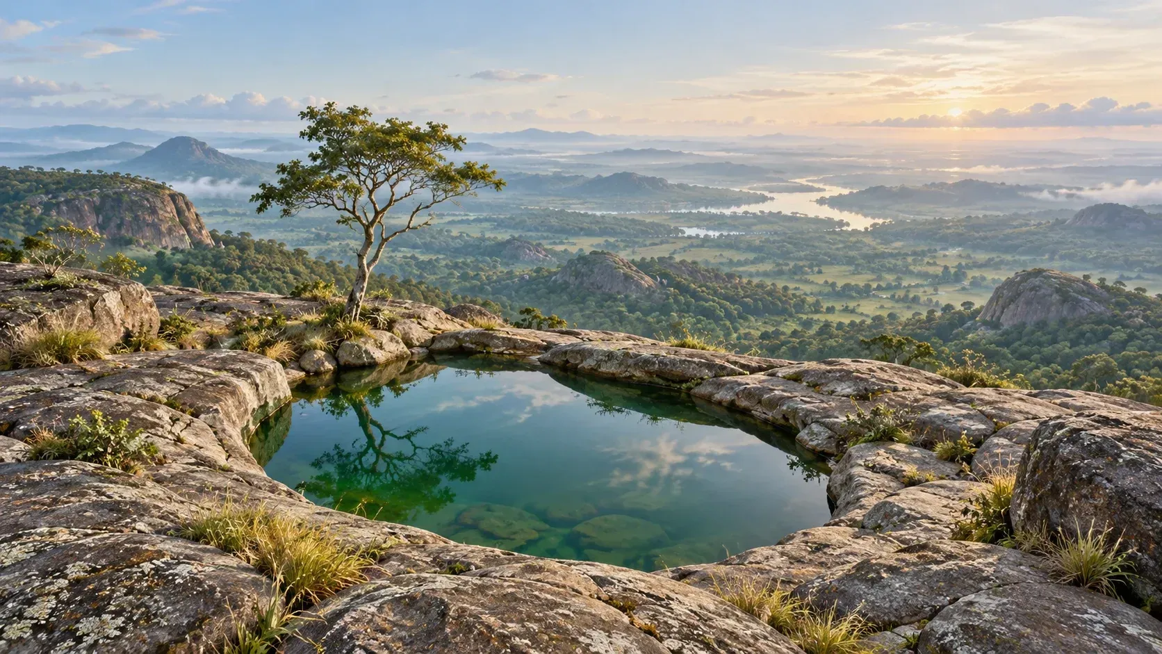
The difference may sound pedantic until you see where the lake is. It occupies a rocky hollow high on Oke Ado Mountain, above Ado-Awaye in Oyo State. The view across the surrounding country is expansive. The water itself, in photographs, looks quiet enough to fit within a modest landscape garden. Between that small surface and the stories told about what lies underneath, a surprising amount of history has accumulated.
The climb comes before the mystery
Ado-Awaye sits in southwestern Nigeria, roughly west of Iseyin. Above it rises an extensive rocky hillscape. Visitors follow a steep path and steps past formations that have names, histories and traditional meanings of their own.
Guidebooks have never quite agreed on the arithmetic of the climb. The official Ramsar information sheet describes approximately 350 steps. A Guardian report from December 2024 counted 369. Visitor accounts describe different walking times depending on fitness, the route and the number of stops. These differences are not evidence of anything mysterious. They remind us that a hill is harder to reduce to a brochure than a headline suggests.
The reward is unusual enough without embellishment. From the open rock around the lake, the wider landscape falls away in ridges and green stretches. Within that elevated setting lies a pool of dark green water, edged by stone and vegetation. Its surface can mirror the sky so completely that the boundary between rock and reflection seems to move with the clouds.
The term suspended lake has helped make Iyake famous. It also causes confusion. The lake is not floating in the air. It rests in a natural depression on high ground. Nor is “suspended lake” a universal scientific category with an agreed global inventory. Articles frequently declare it one of just two such lakes in the world, usually naming Colorado's Hanging Lake as the other. That comparison may be memorable tourism language, but a claim that only two elevated natural lakes exist worldwide requires a definition and an authoritative count the sources do not provide.
The unusual setting is real. The numerical superlative is less secure.
Local identity is woven into the landscape. Oyo State's own description of the mountain tells of people moving between the settlements of Ado and Awaye, of refuge on the heights and of landmarks revered across generations. Those historical traditions are recorded as local accounts, not as precisely dated episodes reconstructed from excavation reports.
The hill is therefore both a physical place and a series of remembered places. Before a visitor reaches the water, the path has already suggested that rocks can carry stories without ceasing to be rocks.
The crying woman and the water that kept her name
One explanation of the name Iyake connects it with a woman's cry.
The story is told in more than one form. In widely circulated versions, a woman unable to have children was mocked or distressed, came to the mountain and died in or near the lake. Some retellings say she wept so bitterly that the water became associated with her grief. Others connect the lake more broadly with a protective or fertile feminine presence. The Guardian reported in 2024 that local people linked the name to a weeping woman who fell into the water and to beliefs about fertility.
It would be irresponsible to turn this into an authenticated biography. No source examined here identifies a contemporaneous record of the woman's life, gives a securely established date for her death or demonstrates that the water first appeared at that moment. One visitor's account even describes the lake as existing before the woman's death. That variation is precisely what one expects when several versions of a traditional narrative circulate.
The emotional logic is clearer than the chronology. A place that holds water becomes associated with a woman whose life was shaped by longing, exclusion and grief. The same water then becomes, in other tellings, a place where people pray for the very thing she was denied.
These beliefs deserve to be described without pretending that they are medical findings. Accounts of fertility and healing at Iyake are religious and cultural traditions. They do not establish that bathing in the lake or drinking its water treats infertility or any illness. Nor should the story of a woman who suffered be reduced to decorative tragedy in a tourist advertisement.
For the community, the name has meaning independently of whether a researcher could ever attach it to one verifiable person. People often inherit a place-name before they inherit an explanation for it. The explanation can change while the name remains.
There is nothing unusual about a lake holding a story. What makes Iyake striking is how much of its reputation depends on the idea that the water does not surrender what enters it.
The people who supposedly never came back
The most frightening claim about Iyake is easy to state: anyone who swims in it will disappear.
Atlas Obscura records a version of that warning. Other tourism accounts describe an unnamed outsider who ignored advice, entered the water and was never seen again. Some simply say that nobody has ever entered and returned. The sources reviewed do not supply a name, date, police record, contemporary report or independently verifiable investigation establishing the alleged disappearances.
That distinction matters. A prohibition on swimming can be a real social rule. A disappearance story can be a real part of local folklore. Neither fact proves that a particular person vanished into the lake, and the absence of documents does not license us to invent one.
There is a nearby feature with an even more alarming name: Agbómofúnyàké. Popular descriptions associate it with a hole in the rock that, when filled with water, is said to pull in anyone who puts a foot inside. The phrase is sometimes explained in retellings as the place that takes a child and gives it to Iyake. Translation and spelling vary among sources; it would be unwise to treat an English gloss as a definitive linguistic analysis without local expert confirmation.
The hole is a separate feature of the landscape, not proof of an underwater passage beneath the lake. No credible survey provided in the reviewed sources establishes that it connects to a subterranean world or that anyone was physically dragged into it. Its place in the story is symbolic and practical: it is somewhere people have been warned to avoid.
Warnings around deep or unfamiliar water can be valuable even when their supernatural explanations are unverified. Uneven rock, uncertain depth, slippery edges and the absence of a documented safety assessment are sufficient reasons not to experiment with a swim. A visitor should follow current local rules and qualified guides, not test a legend by entering the water.
The question has anyone ever entered Iyake Lake and returned? sounds as though it should lead to a list of names. In the available material it leads instead to a repeating claim with little traceable documentation. That is not a satisfying answer for a ghost story. It is the distinction an honest article has to keep.
What would it take to find the bottom?
Measuring a lake is a technical job, not an act of courage.
The basic task is called bathymetry: mapping the underwater shape of a basin. Surveyors can take depth measurements at known positions, record water levels, and use acoustic sounding equipment to build a picture of the bed. The U.S. Geological Survey describes how echo sounders use the travel time of returning sound waves to produce detailed maps of river and lake bottoms. Sometimes the equipment is carried on a small survey craft; the method and safety precautions depend on the site.
Nothing in that process requires a diver to descend into dark water to discover whether a rock floor exists. In principle, a carefully planned, authorised survey could establish the depth profile and indicate which sections were measured directly and which were estimated between soundings.
That is why the phrase bottomless lake is misleading in two directions. It sounds like a measurement when it is a legend, and it makes a lack of documented measurements seem like evidence of an impossible physical property. A natural lake occupies a basin. Its depth can be difficult to establish or inadequately recorded without being infinite.
The available Ramsar documentation is an instructive example. It gives the date of the site's international designation, a mapped area and a description of rainfall, wetland functions and the surrounding environment. It does not provide a verified maximum depth for the water body. The stated area—165.28 hectares—belongs to the wider designated wetland, not to the tiny visible pool alone. Converting that number into the lake's surface area, let alone its depth, would be a serious mistake.
Other measurements are repeated inconsistently in tourist descriptions: the height of the mountain, the number of steps and even the claim about being one of two lakes worldwide. Rather than silently select whichever figure sounds most impressive, a useful account should identify what each number actually measures and who supplied it.
Could a detailed scientific survey already exist somewhere outside the sources searched here? Certainly. An inaccessible thesis, local engineering record or unpublished study would change the answer. The accurate statement in October 2026 is narrower: no publicly verifiable maximum-depth sounding was established in the sources consulted for this article.
It is possible to admire a mystery while wanting a better instrument reading. The two impulses need not cancel each other.
The mountain's other witnesses
Ado-Awaye's best-known lake is not its only named landmark.
One of the rock formations encountered on the route is Ishage Rock, a large balanced boulder treated with reverence in local tradition. Oyo State's tourism description records a story in which a ritual involving white cloth and prayers at the rock is connected with bringing rain during drought. Atlas Obscura recounts a similar belief. These are accounts of what people say and practice, not proof that a boulder controls the weather.
Elsewhere are depressions commonly called Esè Àwọn Àgbà, or footprints of the elders or gods in popular English renderings. Some writers have suggested that the marks might be connected with former human activity, such as grinding. No archaeological assessment examined here fixes their origin beyond doubt. The landscape invites rival readings because the markings resemble something familiar: the trace of a step.
Together with Iyake, these sites form a route through the way human beings recognise patterns. A footprint shape becomes a story about who walked there. An apparently balanced stone becomes a place for petitions about rain. A dark pool becomes the home of someone whose grief was said to be too great to leave behind.
There is no need to mock those meanings, and no need to label them laboratory results. They are part of the cultural history of the site. That cultural history is one of the reasons the mountain attracts pilgrims and visitors alongside hikers.
At the same time, it creates a practical problem for any institution responsible for managing access. A site can be ecologically vulnerable precisely because it matters to so many people for different reasons. The path must serve visitors without making the place disposable. The surrounding vegetation and rock formations are not props to be rearranged for a photograph.
This is where the story of the lake, usually told as ancient and timeless, enters the very recent past.
The lake that acquired an international file number
On 1 March 2024, the Ado-Awaye (Iyake) Suspended Lake Wetland was designated a Ramsar site. Its registration number is 2550.
This is a real international conservation designation, distinct from a UNESCO World Heritage inscription. The listed area covers 165.28 hectares of the surrounding wetland environment. It is not a claim that the lake contains 165 hectares of open water. The Ramsar information sheet describes ecological and cultural values, including water storage, vegetation and habitat. It also identifies human activity and environmental pressures as management concerns.
A familiar question follows: if a place is internationally recognised, is it automatically protected from everything that can damage it?
No. Listing establishes recognition and a framework for conservation; its effect depends on management, resources and the people responsible on the ground. The paperwork is the beginning of a responsibility, not a force field around the mountain.
A December 2024 Guardian report described the difficulty of drawing visitors to Ado-Awaye and the local frustration with limited facilities. A government investment document issued in 2025 likewise described steep access, minimal visitor infrastructure and opportunities for better management. Those accounts refer to their respective dates; they cannot be treated as a live report on the condition of every path in October 2026.
There was a further administrative development on 3 March 2026. Nigerian newspapers reported that Oyo State had signed an agreement giving the Araromi Local Council Development Area temporary responsibility for managing the attraction while a longer-term arrangement was sought. That is evidence of a management decision, not evidence that new facilities have already been built.
For a lake surrounded by stories of an unseen world, these are ordinary developments. Someone has to organise access, maintain safe surroundings, protect the wetland and decide how tourism will operate. The lake's ability to hold people's attention does not maintain the trail or safeguard the ecosystem by itself.
The newest story attached to Iyake is therefore not about a person who vanished into it. It is about the people and institutions responsible for making sure the lake itself does not deteriorate while the legends continue to circulate.
What remains unknown
A visitor could arrive at Iyake with one question—is it really bottomless?—and come away with several that have better answers.
It is an actual lake in a rock basin high above Ado-Awaye. It has been described in government publications, visited by tourists and recognised as part of a wetland of international importance. Its name and nearby landmarks carry longstanding local narratives about grief, fertility, danger and rain. A dangerous-swimming legend is not the same thing as a documented drowning. The claim that only two comparable lakes exist in the world is not supported by a consistently defined global scientific category.
The exact maximum depth remains unverified in the accessible material examined here. That does not make the water bottomless, and it does not make a future measurement impossible.
Perhaps one day an authorised survey will produce a reliable depth map, complete with contours and the unromantic measurements that good science requires. That would settle a physical question. It would not erase the grieving woman from the place-name, topple Ishage Rock or take away the meanings generations have attached to the mountain.
Meanwhile, the lake continues to do what the photographs show it doing: sitting quietly in stone, holding the sky on its surface. The number 2550 tells us which protected place it is. The number that would tell us how far the water goes down is still missing from the public record we could verify.
Sources and further reading
- Ramsar Sites Information Service — Ado-Awaye (Iyake) Suspended Lake Wetland, Site 2550 (external platform)
- Atlas Obscura — Iyake Suspended Lake (external platform)
- Oyo State Government — Oyo State at a Glance (2020) (external platform)
- The Guardian — Beaches, Beer and a Rare Suspended Lake (28 December 2024) (external platform)
- U.S. Geological Survey — Hydrographic Surveys of Rivers and Lakes Using a Multibeam Echosounder (2018) (external platform)
- Punch — Oyo Hands Over Management of Iyake Suspended Lake to LCDA (3 March 2026) (external platform)