Articles / LORQAI
Why Are There Thousands of Chocolate Hills?
On the Philippine island of Bohol, thousands of remarkably similar limestone hills reveal a story of ancient marine sediments, tectonic uplift, and millions of years of tropical weathering.
Introduction
Imagine standing above a landscape that seems to have been arranged by someone with an extraordinary sense of patience.
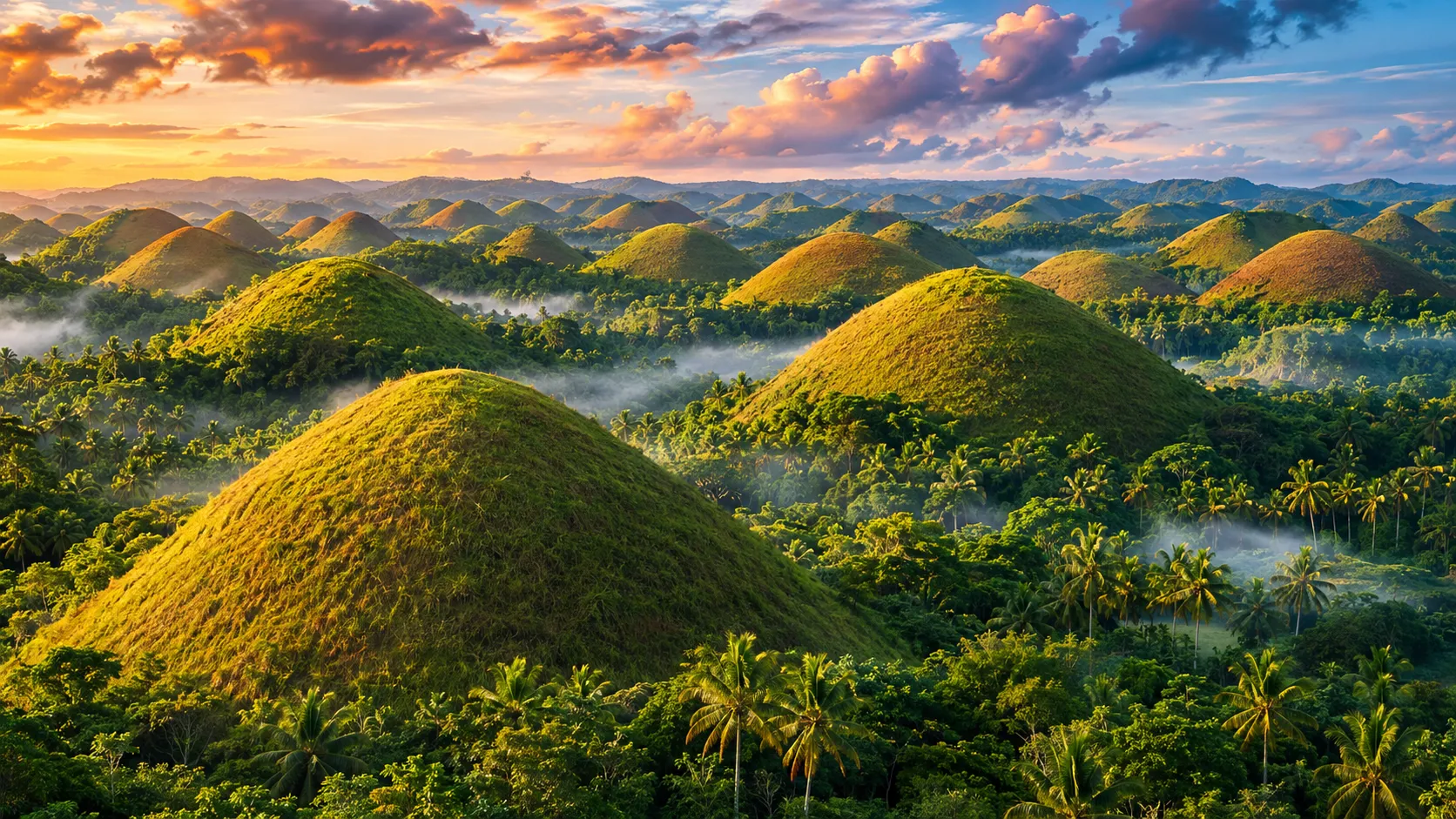
One rounded hill rises from the ground. Then another. Then hundreds more, stretching toward the horizon.
They are separated by valleys and patches of green. Many have gently pointed summits and remarkably similar slopes. From a distance, the whole landscape resembles an enormous collection of carefully shaped mounds.
There are no obvious volcanoes, no towering mountain peaks, and no giant machinery capable of producing anything like it.
Yet here they are.
These are the Chocolate Hills of Bohol, in the central Philippines.
And the strangest thing about them is not their name.
It is how nature managed to make so many hills look almost alike.
A Landscape That Looks Almost Too Orderly
The Chocolate Hills are among the most recognizable landscapes in the Philippines.
The protected landscape is commonly described as containing approximately 1,776 hills, although published counts differ depending on the area and method of counting.
They are concentrated across several municipalities of Bohol, especially Carmen, Batuan, and Sagbayan.
Viewed from above, many resemble cones with rounded tops. Some are higher, some wider, and others less symmetrical. They are certainly not identical, but the repetition of their general shape is unusual enough to make the landscape appear almost designed.
That appearance inspired generations of stories.
One local legend tells of two giants who fought by throwing enormous masses of earth at each other. When their battle ended, the scattered material remained behind as hills.
It is an imaginative explanation for an extraordinary sight.
The geological story, however, is even more surprising.
Because long before these hills existed, much of the material that formed them was accumulating beneath the sea.
The Hills Began as a Marine Landscape
To understand the Chocolate Hills, we have to imagine Bohol looking very different from the island we know today.
Millions of years ago, marine environments supported the accumulation of coral-derived material and other calcium-carbonate sediments.
Over time, this material became limestone.
Limestone is a sedimentary rock, commonly formed from the accumulated remains of marine organisms and the precipitation of calcium carbonate.
Unlike volcanic rock, it does not require an eruption to form.
The limestone associated with the Chocolate Hills developed from an ancient marine carbonate platform. UNESCO describes the relevant coral-reef buildup as dating to the Pliocene, approximately two to five million years ago.
But limestone forming underwater does not automatically explain hills standing on dry land.
Another process had to intervene.
The ground itself had to rise.
Bohol lies in a geologically active region of the Philippines, where tectonic forces have shaped the islands over immense periods of time.
These movements helped lift former marine deposits above sea level.
What had once accumulated in an underwater environment eventually became exposed to tropical weather.
And once rain began falling on the exposed limestone, a slow geological transformation could begin.
The Rain That Gradually Reshaped the Rock
Rain may seem too gentle to carve a landscape of thousands of hills.
But limestone has a particular weakness.
It can slowly dissolve in water that is slightly acidic.
As rainwater passes through the atmosphere and soils, it can absorb carbon dioxide. This produces weak carbonic acid, which reacts with calcium carbonate in limestone.
The process is not dramatic on the scale of a single afternoon.
A person watching the same limestone hillside for a few hours would see very little happening.
But the effects accumulate.
Water enters cracks, moves through fractures, and follows channels through the rock. Some pathways gradually widen. Material is removed from parts of the landscape, while more resistant or less exposed portions remain.
This type of terrain is called karst.
Karst landscapes can contain caves, sinkholes, underground drainage systems, steep rock formations, and isolated hills.
On Bohol, prolonged dissolution and erosion helped transform a broad limestone surface into an extraordinary landscape of rounded and conical elevations.
The hills are not piles of loose soil placed upon the land.
They are surviving parts of a limestone landscape that has been reshaped around them.
In a sense, the Chocolate Hills are a record of what water removed as much as what it left behind.
But Why Do So Many Hills Look Similar?
This is the question that makes the Chocolate Hills particularly fascinating.
Limestone landscapes occur in many parts of the world.
They do not all produce thousands of similarly shaped hills.
Some become jagged towers. Others develop sharp ridges, deep sinkholes, or irregular cliffs.
So why did Bohol develop such an unusually repetitive pattern?
Researchers have studied the Chocolate Hills as a distinctive example of tropical karst, sometimes described as cone karst.
A 2011 scientific study by geographer Jean-Noël Salomon examined their formation and emphasized the importance of the former limestone platform and the relatively consistent tropical conditions under which karst processes developed.
The characteristics of the underlying rock matter. So do its fractures, the movement of water, soil cover, vegetation, and the local climate.
Together, these factors can influence the way rock is dissolved and slopes evolve.
Where broadly comparable materials are exposed to broadly comparable weathering conditions over long periods, some similarity in the resulting landforms is understandable.
But that does not mean every hill grew according to an identical formula.
Differences in local rock structure and drainage still matter. The hills vary in size, shape, spacing, and height.
Their apparent uniformity becomes especially striking when we look across the landscape from a distance.
The important point is that their shapes emerged through natural geological processes, not through the deliberate construction of separate mounds.
The remaining question is not whether erosion played a role.
It is how the island's particular combination of rock, climate, drainage, and geological history produced such an extensive and distinctive field of hills.
That question is part of what makes the Chocolate Hills scientifically interesting.
Why Are They Called Chocolate Hills?
For much of the year, the name can seem rather confusing.
The hills may be vividly green, covered with grasses that respond to the tropical climate.
Then the dry season arrives.
As available moisture decreases, the grass covering many of the slopes dries and becomes brown.
The green hills begin to resemble a landscape of giant chocolate-colored mounds.
The rock underneath has not suddenly changed color.
The visible transformation comes primarily from the vegetation.
This seasonal difference gives the same landscape two quite different appearances.
During greener periods, the hills can look soft and almost unreal, like a repeated pattern of living green cones.
In drier conditions, their brown slopes make the origin of the name much easier to understand.
It is a reminder that what we see in a landscape is often the combined result of geology and living ecosystems.
The limestone determines the basic landform.
The vegetation changes its visible character.
A Geological Landscape Worth Protecting
The Chocolate Hills are more than a photogenic curiosity.
Their geological significance has been formally recognized for decades.
In 1988, the area was declared the Philippines' third National Geological Monument.
In 1997, a presidential proclamation established the Chocolate Hills Natural Monument, identifying approximately 1,776 hills and surrounding areas for protection.
The protected area's boundaries were subsequently amended in 2003, particularly in relation to certain lands between the hills.
The Chocolate Hills Natural Monument was also placed on the Philippines' UNESCO World Heritage Tentative List in 2006.
That does not mean the Chocolate Hills have already been inscribed as an individual UNESCO World Heritage Site.
There is, however, another important recognition.
In 2023, Bohol Island became the Philippines' first UNESCO Global Geopark.
The geopark includes a wider geological landscape, with limestone formations, caves, other geological features, and places that reveal the island's long and complicated history.
UNESCO Global Geopark recognition highlights the relationship between geological heritage, education, conservation, and local communities.
It also makes an important point about places such as the Chocolate Hills.
Their value does not end when someone has taken a photograph.
The rocks, soils, vegetation, waterways, and communities around them are all part of a living landscape.
Protecting the hills means protecting more than their outlines against the sky.
What the Chocolate Hills Tell Us About Time
Perhaps the most remarkable thing about the Chocolate Hills is the contrast between their appearance and their history.
They look simple.
A mound. A slope. A rounded summit.
Repeat the shape across the landscape, and the result is extraordinary.
Yet the processes behind them involve ancient marine environments, changes in sea level, tectonic uplift, limestone dissolution, tropical weathering, and the slow reorganization of the land.
No single storm made these hills.
No single earthquake sculpted them into their present forms.
Their landscape developed through an accumulation of changes operating over geological time.
We often imagine geological forces as violent events: mountains rising, volcanoes erupting, earthquakes splitting the ground.
The Chocolate Hills offer a different perspective.
Sometimes a dramatic landscape emerges because ordinary processes continue for an extraordinarily long time.
Water falls.
Water moves.
Rock dissolves.
Valleys deepen.
And the shapes that remain gradually become the hills we recognize today.
The Chocolate Hills may look as though they were placed on Bohol one by one.
In reality, they are remnants of a much older landscape, revealed and reshaped by time.
And perhaps that is what makes them so compelling.
Nature did not need to build thousands of matching monuments.
It needed limestone, water, movement, and patience.
Listen & explore
- UNESCO — Bohol Island Global Geopark (external platform)
- Salomon (2011) — Acta Carsologica research (external platform)
- National Museum of the Philippines — Geology of Karst Forests (external platform)
- UNESCO — Chocolate Hills Natural Monument Tentative List (external platform)
- Philippine Supreme Court E-Library — Proclamation No. 333 (2003) (external platform)