Articles / LORQAI
The Island That Keeps Editing Its Own Map
Why Sable Island changes shape, how its moving sands bury and reveal history, and what happens when the coastline refuses to stay where it was drawn.
A remote Atlantic island keeps changing its shape. Its dunes move, its freshwater ponds shift, and storms reveal centuries-old shipwrecks. Meet the island that refuses to stay on the map.
By LORQAI
The Island and the Map
There is a small administrative difficulty with Sable Island.
It will not remain the shape in which it was recorded.
Draw its coastline carefully. Measure the beaches. Mark the dunes, the freshwater ponds and the narrow strips of sand reaching into the Atlantic Ocean. Produce a beautiful map with convincing lines and enough detail to satisfy even the most demanding cartographer.
Then put the map away.
The island will get on with making it obsolete.
Not immediately, of course. Sable Island does not rearrange itself overnight like furniture in an unfamiliar hotel. But its beaches erode, its dunes migrate, its sandbars change and its exposed surfaces are worked continuously by wind and water.
An island is usually represented on a map as a fixed piece of land surrounded by sea.
Sable Island takes exception to the word fixed.
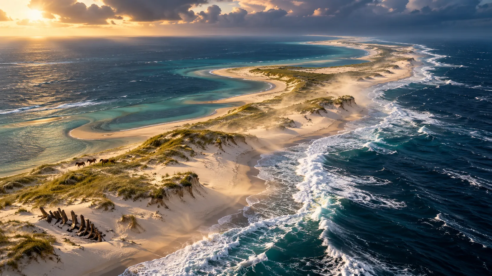
Situated roughly 290 kilometres southeast of Halifax, Nova Scotia, it forms a narrow crescent near the edge of the continental shelf. The island is approximately 42 kilometres long, although giving precise dimensions to something so changeable requires a date.
It has no towering mountains, no great forests and no permanent city.
It has sand.
An extraordinary quantity of sand.
And an exceptionally energetic relationship with the Atlantic Ocean.
The result is one of the strangest geographical documents imaginable: an island whose outline is always correct for a particular moment and increasingly questionable for every moment that follows.
To understand it, we need to make several corrections to the conventional idea of what an island is.
Correction One: Land Does Not Have to Be Solid
A rocky island seems reassuringly permanent.
Even if waves gradually wear away its coast, the underlying stone suggests something resistant to change. A cliff can retreat, but it generally does so with the considerable dignity expected of a large piece of geology.
A sand island is less committed to keeping its existing arrangements.
Sable Island consists primarily of sand and gravel originally deposited through glacial processes. Its surface is shaped by waves, currents, wind and the growth of vegetation.
The sand is not merely lying there.
It travels.
Waves move sediment along the shore. Wind carries dry grains inland. Sand collects around obstacles, building small mounds that may develop into dunes. Unvegetated dunes can shift, while grasses and other plants help stabilize parts of the landscape.
This creates a complicated system of movement.
During some seasons, winds carry large quantities of sand away from the island's exposed surfaces. Waves and currents redistribute material along the coastline and may return sediment to other locations.
The process is not as simple as one enormous conveyor belt moving the entire island in a single direction.
Different parts can behave differently.
A stretch of beach can retreat while another gains sediment. A dune can grow, collapse or migrate. A long sandy point may extend into the sea, only to be shortened by later storms.
The overall outline changes because many smaller changes are happening at once.
This makes the question Is Sable Island moving? both reasonable and slightly misleading.
It is certainly changing. Its sand and shorelines are mobile. Historical records document substantial changes to its ends and coastal shape.
But the island should not be imagined as a rigid object drifting across the ocean like a boat with an unusually large garden.
It is a geographical formation being continually rebuilt from its own material.
That distinction matters.
A boat changes position while remaining broadly the same object.
Sable Island can remain in the same general location while becoming different in shape, width and internal arrangement.
The mapmaker has not necessarily put the island in the wrong place.
The island has changed what occupies that place.
Correction Two: The Coastline Is a Temporary Agreement
Imagine placing two maps of Sable Island beside one another.
The first was made in the eighteenth century. The second was produced using modern aerial photographs and surveys.
They show the same island.
They do not show the same outline.
This is more than a matter of improved surveying equipment. Sable Island has undergone genuine physical changes during the intervening centuries.
Historic charts show different configurations of the narrow sandy ends, the lagoons and the interior landscape.
Parks Canada has reproduced maps dating from the 1760s onward to illustrate changes in the island's shape and the development of its freshwater features.
Older accounts sometimes described the island as shifting eastward. Other periods showed movement in the opposite direction.
That is another reason to avoid treating the island as a single object traveling steadily along a predetermined route.
Its changes are not uniform.
The eastern and western ends can gain and lose sand at different times. The long beaches can narrow or widen. The dunes can change how the interior landscape is connected.
More recent analysis adds another detail.
A study of aerial photographs covering the period from 1959 to 2019 found that Sable Island became narrower along parts of its north-south axis. Erosion along the southern shore was not fully balanced by gains on the northern side.
That is a measurable long-term change, not simply an impression created by comparing two photographs after a storm.
Still, any prediction about the island's future has to account for the complexity of its sediment system.
Sand may be removed from one location and deposited somewhere else. A powerful storm can reshape a shoreline dramatically. Vegetation can help stabilize some dunes while other areas remain exposed.
Natural Resources Canada has discussed these problems through the work of researchers examining Sable Island's changing coastal landscape.
Their findings describe significant changes and real risks, but not a simple, precisely dated disappearance of the entire island.
It would be convenient if geography offered a permanent coastline, together with an expiration date for the map.
Instead, the ocean keeps revising the terms.
Sometimes it removes a beach.
Sometimes it delivers another.
And every revision is written in sand.
Correction Three: There Is Fresh Water in the Middle of the Ocean
An island surrounded by salt water might seem an unlikely place to find freshwater ponds.
Sable Island has them.
This detail would be less surprising if the island contained a mountain stream, a river or a complicated freshwater system flowing down from high ground.
It contains none of those.
Its freshwater story happens mostly underground.
Rain and fog provide the island's fresh water. The sandy ground allows water to infiltrate rapidly rather than producing the familiar network of streams found in many other landscapes.
Beneath the surface, fresh groundwater forms what geologists call a freshwater lens.
Fresh water is less dense than salty seawater. In suitable coastal conditions, it can accumulate above the denser saline groundwater.
The result is a hidden body of fresh water within an island surrounded by the Atlantic.
Where the lens intersects low-lying areas, freshwater ponds can appear.
These ponds are concentrated in the western part of Sable Island. Farther east, horses can obtain water by digging shallow holes in the sand to reach groundwater.
This makes the island's natural plumbing considerably more ingenious than its appearance suggests.
A person looking at a sandy beach may see nothing more than sand.
Beneath it lies a system that helps sustain living creatures far from the mainland.
But the arrangement is vulnerable.
Windblown sand can fill ponds. Changes to the dunes can alter low areas. Saltwater can enter freshwater systems during flooding or other events.
The history of Lake Wallace illustrates the problem.
This former water feature changed over time, becoming smaller as the island's geography evolved. Today its old basin is associated with active dune formation and vegetation colonization.
A landscape that once held open water can become a landscape of sand and plants.
This is another inconvenience for the cartographer.
A map does not merely need corrections to the coastline.
It may need to delete a lake.
Or revise the position of a dune.
Or record a new wet area where the underlying water has become exposed.
All this happens without anyone acquiring the land, obtaining planning permission or requesting a change of address.
Correction Four: The Residents Have Not Been Consulted
Sable Island's most famous inhabitants are its wild horses.
They are an extraordinary sight: stocky, often shaggy animals living among dunes and Atlantic beaches, far from the farms and fields more commonly associated with horses.
Their ancestors were introduced to the island during the eighteenth century. The present population has lived there for generations, and the animals are protected.
The horses have adjusted to an environment with few of the familiar conveniences of domestic life.
They feed on island vegetation. They use the dunes for shelter from strong winds. They move between feeding and watering areas, following routes through the changing landscape.
They also participate in that landscape.
Their movement creates paths. Their grazing affects vegetation. Changes in the distribution of plants can influence how exposed sand behaves.
Sable Island is therefore not simply a pile of sediment acted upon by weather.
It is an ecosystem in which living organisms and physical processes interact.
The horses are only the best-known residents.
Grey seals gather along the shores, particularly during the breeding season. Birds use the island as nesting and resting habitat. Specialized plants and insects occupy environments that are uncommon elsewhere.
The island's dunes provide more than scenery.
Vegetation helps hold sand in place. Dune formations offer shelter and habitat. Freshwater ponds support plants and animals that could not simply rely on seawater.
This creates a fascinating contradiction.
The island's ecology depends on a landscape that is naturally unstable, while some of its inhabitants help stabilize parts of that landscape.
Plants can catch windblown sand and encourage a dune to grow.
Animals can disturb vegetation and expose the surface again.
A storm may undo years of local accumulation.
None of these processes needs to be interpreted as an error.
They are part of how the island functions.
That does not mean every change is harmless or that its future is guaranteed. Changing environmental conditions can affect habitats and the species that depend on them.
But the landscape cannot be understood by assuming that a perfectly preserved version of today's coastline would represent its only healthy condition.
Sable Island has always been dynamic.
Its residents live with that dynamism rather than with the neatly bordered territory shown on a classroom map.
A horse can follow a path across the dunes.
The path does not have to exist forever.
Correction Five: The Past Is Not Always Where You Left It
Now comes the part of the story that feels suspiciously like an adventure novel.
Sable Island has a long history of shipwrecks.
More than 350 wrecks have been recorded around its shores. Fog, difficult weather and shifting sandbars made the area dangerous to mariners, particularly before modern navigation and rescue systems.
The island acquired the ominous nickname Graveyard of the Atlantic.
In 1801, a lifesaving establishment was created to assist people shipwrecked on or near the island. Human presence has continued there in various forms since that period.
Many ships never completed their journeys.
Their remains became part of the island's historical record.
But unlike an archaeological site preserved beneath stable ground, shipwreck material on Sable Island can be buried, exposed and moved as the sand changes.
This became particularly important in 2024.
After a winter storm, Parks Canada personnel noticed exposed wreckage along the shore. Among the finds was copper sheathing bearing markings associated with the British Royal Navy.
The discovery led researchers to examine historical records of ships lost in the area.
One particularly significant event occurred on September 27, 1812, when HMS Barbadoes and two accompanying vessels, the Swift and the Emeline, were wrecked on Sable Island.
The archaeological evidence suggested that the newly exposed remains could be connected to that event.
Researchers returned for surveys and excavations in 2024 and 2025.
The work involved terrestrial and underwater archaeology specialists, collaborating with Mi'kmaw archaeological personnel.
This was an unusual archaeological assignment.
A shipwreck normally suggests work beneath the sea, perhaps involving divers and underwater equipment.
Here, portions of a wreck were being investigated within the island's sand.
The researchers documented structural elements and collected evidence that could help identify the vessel.
By May 2025, they had uncovered a larger section of wooden hull than initially expected.
The working interpretation was that the remains might belong to the Swift, although the identification required further research.
That distinction matters.
An exciting historical possibility is not the same as a conclusively identified ship.
The archaeologists did not simply announce that the sand had returned a named vessel and declare the mystery solved.
They examined construction details, material evidence and historical records to determine what the surviving remains could support.
And there was another complication.
The sand was still moving.
The conditions that had exposed the wreck could eventually cover it again.
Parks Canada described the need to document the site while the remains were accessible, because shifting dunes could rapidly change what was visible.
Imagine the logistical problem.
You have spent considerable effort locating an important historical object.
You have researched its possible identity, assembled specialists and arranged an excavation.
Meanwhile, the landscape responsible for hiding it has not agreed to stop doing so.
The site is an active geological environment, not a museum cabinet.
At the end of the excavation, portions of the remains were deliberately covered again to help preserve them.
That is perhaps the strangest detail of all.
A storm and shifting sand revealed a possible historical discovery.
Researchers studied it.
Then the material was returned to the sand for protection.
The island had briefly opened part of its archive.
The archivists took notes.
The archive closed again.
Correction Six: A Map Can Be Accurate and Still Be Old
The conventional map creates a useful illusion.
It reduces a complicated world to a stable arrangement of lines and symbols.
A road has a route. A river has a course. An island has a boundary.
We know that roads can be rebuilt, rivers can change and coastlines can erode. But the map presents them as fixed because a map must describe a particular state of the world if it is to be useful.
Sable Island makes that limitation unusually visible.
Its outline is not wrong merely because it differs from an earlier chart.
The earlier chart may have been correct for its own time.
The difference is evidence.
Compare maps from different years, and the changing shape becomes part of the record. What appears at first to be disagreement between documents can reveal the physical history of the landscape.
This is why modern researchers use aerial photography, satellite observations, field surveys and historical mapping to study the island.
A single image shows a condition.
A sequence of images can show a process.
The distinction is enormously important for places like Sable Island.
A shoreline observed after a winter storm may differ from the one recorded during a calmer period. One end of the island may experience substantial change while another remains comparatively stable.
Researchers therefore need more than a beautiful photograph.
They need measurements, dates, repeated observations and an understanding of the forces moving the sand.
Parks Canada established Sable Island National Park Reserve in 2013, recognizing its unusual ecological and cultural significance.
Protecting such a place requires attention to change rather than the assumption that every feature should remain where it was found.
An old building may need monitoring as the surrounding ground erodes.
A sensitive dune may require protection from unnecessary disturbance.
An archaeological site may become exposed unexpectedly and demand rapid documentation.
Wildlife habitats may shift as the terrain changes.
And the people managing the island must make decisions with the knowledge that the environment will continue changing after those decisions are made.
For visitors, the same reality introduces practical restrictions.
Sable Island is extremely remote, and entry requires permission from Parks Canada or travel with a licensed operator. The terrain contains fragile dunes and protected wildlife, and ordinary tourism infrastructure is limited.
It is not a destination where visitors should casually drive across the sand or collect historical objects as souvenirs.
The island is already complicated enough without people helping to rearrange it.
A Small Note in the Margin
Imagine an atlas that includes Sable Island.
Its coastline is printed carefully. The island appears as a narrow crescent in the Atlantic. The surrounding blue is uninterrupted by cities or highways. A small name identifies the land.
There is not much room for explanation.
Perhaps the cartographer could add a footnote:
Shoreline subject to change.
Accurate, but rather understated.
It does not convey the dunes, the freshwater hidden beneath the sand, the wild horses following paths through vegetation or the remains of ships that storms may reveal after centuries.
Nor does it explain that the island's changing shape is not merely an inconvenience to geography.
The changing shape is part of what makes the place what it is.
An atlas requires a clean outline. Researchers require dated evidence. Mariners need reliable navigational information. Ecologists need to understand shifting habitats. Archaeologists must record what the sand exposes before it disappears from view again.
All of them are dealing with the same island.
They simply need different versions of its story.
Sable Island will continue to appear on maps, sometimes a little narrower, sometimes with altered ends, with features that no longer match those printed in older editions.
The next survey may reveal another change.
The next storm may erase a familiar contour.
And somewhere beneath the dunes, a piece of history may be waiting for the sand to move aside.
The mapmaker can draw the island again.
The island has never promised that this will be the final edition.