Articles / LORQAI
The Volcano Inside a Lake
Why Taal Volcano rises from a lake inside an ancient volcanic caldera, how its 2020 eruption reshaped the crater lake, and how scientists monitor its ongoing activity.
Introduction
On the Philippine island of Luzon, a volcano rises from the middle of a lake that occupies an even larger volcano. Its crater once held another lake with a tiny island inside. Then an eruption changed everything.
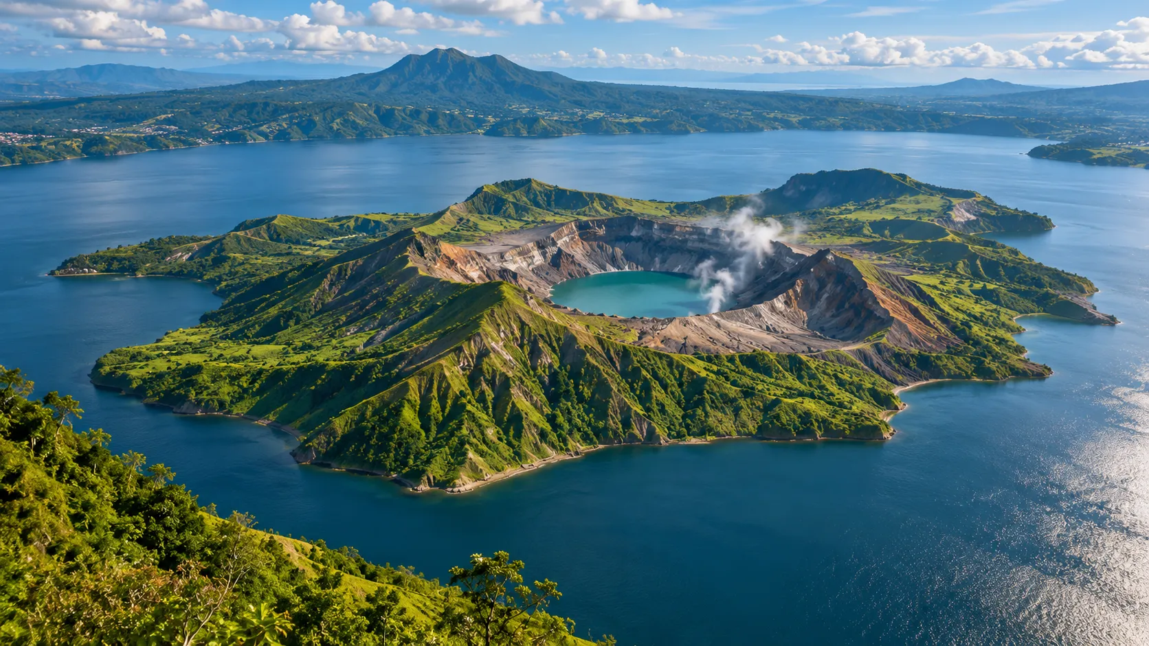
Imagine looking down from a mountain ridge toward an enormous blue lake.
Near its center sits a green island, surrounded by calm water.
There is something peculiar about this island.
It is not simply a piece of land that happens to rise above the surface.
It is part of an active volcano.
And the lake surrounding it is not an ordinary lake, either.
It occupies a huge depression left by an older volcanic system.
For years, the island even contained another lake, inside a crater, with a small rocky island rising from the water.
A lake within an island within a lake.
It sounds like a geographical puzzle invented to confuse someone reading a map.
But this is Taal Volcano, in Batangas Province, on the Philippine island of Luzon.
And its extraordinary arrangement is the result of volcanic eruptions, collapsing ground, changing water levels, and geological processes that continue today.
To understand Taal, we have to begin with a surprising idea.
The volcano is much larger than the island we can see.
The Volcano You Cannot See All at Once
When people imagine a volcano, they often picture a tall, symmetrical cone.
A mountain rises from the surrounding land, narrowing toward a summit crater. During an eruption, ash, gases, and molten material escape from its upper reaches.
Some volcanoes do resemble that familiar picture.
Taal does not.
The visible Volcano Island is only one part of a much larger volcanic complex.
The surrounding Taal Lake occupies a broad volcanic depression known as a caldera.
According to the Smithsonian Institution's Global Volcanism Program, the Taal, or Talisay, caldera measures approximately 15 by 20 kilometers.
Much of this depression is filled by a freshwater lake covering roughly 267 square kilometers.
Inside that lake stands Volcano Island, approximately five kilometers across.
The island contains numerous volcanic features, including small cones, craters, and deposits formed during different eruptions.
What appears to be a single mountain is therefore a collection of geological structures produced by repeated volcanic activity.
The central island is not the entire volcano.
It is an active part of a much older and larger system.
This distinction explains why Taal looks so unusual from the surrounding hills.
We are not simply looking at a volcanic island in a lake.
We are looking across a landscape that has itself been shaped by the formation of a vast volcano.
How Can a Volcano Become a Lake?
The answer begins with a geological event that can be far more dramatic than the slow growth of a volcanic mountain.
Some large eruptions remove enormous quantities of magma from underground.
As magma leaves a reservoir, the rock above may lose part of its support.
If enough material is evacuated and the underground structure can no longer support the overlying rock, parts of the surface can collapse.
The resulting depression is called a caldera.
A caldera is not necessarily a simple circular hole.
Its shape depends on the structure of the volcanic system, the distribution of faults, and the history of collapse.
The Taal caldera developed through powerful prehistoric volcanic activity.
Over time, water accumulated within the depression.
Rainfall, streams, groundwater, and the surrounding drainage system helped establish the lake visible today.
The present lake is therefore part of a landscape shaped by both volcanism and water.
But the story did not end when the caldera filled.
Volcanic activity continued inside it.
New eruptive centers developed.
Ash, fragmented rock, and other volcanic materials accumulated around vents.
Successive eruptions gradually created the landforms that make up Volcano Island.
The result was an unusual arrangement.
An older volcanic depression became a lake.
And younger volcanic features formed an island inside that lake.
Taal is a reminder that the landscape left by one eruption can become the stage for many others.
A Lake Inside an Island Inside a Lake
The geography becomes even stranger when we look at the middle of Volcano Island.
One of its best-known features is the Main Crater.
For decades, this crater contained a lake of its own.
That created a remarkable sequence of land and water.
First, there is Luzon, the large Philippine island.
Within Luzon lies Taal Lake.
Inside Taal Lake stands Volcano Island.
Within Volcano Island lies the Main Crater, historically filled with water.
And within that smaller crater lake stood a rocky feature called Vulcan Point.
This arrangement became famous as an island within a lake on an island within a lake on an island.
It was real, not a trick of perspective.
NASA documented the structure using satellite imagery in 2014, identifying Vulcan Point as a rocky remnant emerging from the crater lake.
But there is an important complication.
Volcanic landscapes do not remain unchanged simply because they appear on maps.
In January 2020, Taal erupted violently.
The crater lake changed dramatically.
Within days, Philippine volcanologists reported that the water had disappeared from the Main Crater.
The famous nested landscape had been disrupted by the very geological forces that created it.
The story could have ended there.
But the lake returned.
NASA satellite observations published in March 2020 confirmed that water had accumulated again in the Main Crater after much of it had evaporated or drained during the eruption.
The remarkable nested geography survived in a changed form, although individual features, water levels, and crater conditions could no longer be assumed identical to their pre-eruption appearance.
The lesson is simple.
At an active volcano, even the geography can be temporary.
The Day the Landscape Changed
On January 12, 2020, Taal began a powerful eruptive episode.
Ash and steam rose above the volcano, and volcanic lightning flashed within the eruption cloud.
The plume climbed more than ten kilometers into the atmosphere.
Fine ash spread across populated regions, disrupting transportation, businesses, schools, and ordinary life.
Communities around the lake faced evacuation and uncertainty.
The eruption was an extraordinary event, but it was not unexpected in the broader geological history of Taal.
The volcano has produced numerous recorded eruptions, including destructive events in 1911 and 1965.
The 2020 eruption demonstrated that Taal remained capable of producing sudden and dangerous activity.
Scientists classified important parts of the event as phreatomagmatic.
That word describes an explosive interaction between magma and water.
When hot magma encounters water under suitable conditions, the interaction can fragment molten rock and drive energetic explosions involving steam, ash, and other material.
At Taal, water was not simply part of the scenery.
It helped shape the eruption itself.
Studies of the 2020 event also documented hazardous volcanic base surges: rapidly moving mixtures of gas and volcanic particles that can spread outward near the ground.
These hazards can be especially dangerous because they do not need to follow the narrow path of an ordinary lava flow.
The eruption also generated an electrified cloud.
Research published in the journal *Geology* examined the intense volcanic lightning associated with Taal.
The eruption plume became a powerful thunderstorm-like system, with electrical activity developing as particles, water, and ice interacted within the rising cloud.
The volcano beneath the lake had created a storm above it.
Why Water Makes Some Eruptions More Dangerous
At first glance, water might seem like something that should reduce volcanic danger.
After all, we use water to cool hot objects and extinguish many kinds of fire.
But magma behaves very differently from an ordinary flame.
It can reach temperatures high enough to transform water into steam rapidly.
Under certain conditions, the interaction between magma and water produces explosive fragmentation.
As water heats and expands, pressure can build.
Molten material may break into smaller particles, increasing the area exposed to additional water.
This can contribute to intense explosions.
The process is not guaranteed whenever magma encounters water. The result depends on how the materials interact, the pressure, the water supply, and other conditions.
But it is one reason why volcanic systems containing lakes or underground water require particular attention.
At Taal, scientists also distinguish phreatomagmatic eruptions from phreatic explosions.
A phreatic explosion is primarily driven by steam or heated fluids and does not require the direct eruption of fresh magma.
Both types of events can be hazardous.
The difference matters because small surface explosions do not always indicate that a large new magmatic eruption is underway.
Conversely, relatively small explosions can still endanger anyone nearby.
The presence of water makes the volcano's behavior more complicated, not necessarily more predictable.
The Strange Life of the Crater Lake
The water inside Taal's Main Crater is more than a passive pool.
It can respond to heat, gases, and changes in the volcanic system below.
Volcanic gases may dissolve in crater water, changing its chemistry.
Hydrothermal fluids can raise temperatures and produce visible disturbances.
Scientists monitor features such as temperature, acidity, gas emissions, and changes in the crater's surface conditions.
These measurements offer clues about what is happening beneath the ground.
For example, a change in lake chemistry may indicate changes in the gases or fluids entering the system.
Increased temperature may reflect altered hydrothermal conditions.
An unusual combination of changes might signal increasing unrest.
But no single observation provides an infallible prediction of an eruption.
Crater lakes are complex environments.
Weather, rainfall, gas circulation, water mixing, and volcanic processes can all influence the measurements.
Scientists therefore study several kinds of evidence together.
This is especially important at Taal because the lake sits directly within an active volcanic system.
Its beauty and its danger arise from the same source.
The heat and chemistry that make the water unusual are connected to the processes capable of producing eruptions.
How Scientists Watch a Volcano That Never Fully Sleeps
Monitoring Taal requires more than looking for smoke.
The Philippine Institute of Volcanology and Seismology, commonly known as PHIVOLCS, tracks the volcano using several complementary methods.
One is seismic monitoring.
As rock fractures, fluids move, and volcanic processes disturb the ground, instruments can detect earthquakes and different kinds of volcanic tremor.
Another method involves ground deformation.
Changes in pressure beneath the volcano can cause parts of the surface to expand, tilt, or gradually subside.
Satellite observations and instruments such as GPS receivers help scientists measure these movements.
Gas monitoring provides another important source of information.
Sulfur dioxide emissions can offer evidence about magma-related processes, while changes in carbon dioxide and other gases may reveal shifts in the hydrothermal system.
Scientists also observe the Main Crater Lake.
They monitor its temperature, acidity, and other indicators that can respond to volcanic activity.
The key is to examine the evidence together.
An earthquake swarm does not automatically mean an eruption is imminent.
A change in gas emissions does not provide a precise countdown.
And an apparently quiet crater does not guarantee that a sudden steam-driven explosion cannot occur.
Volcano monitoring is a process of evaluating changing probabilities and hazards, not predicting an exact date with certainty.
That distinction matters for the communities living around Taal Lake.
Scientific monitoring helps authorities recognize unrest and issue warnings.
It cannot eliminate the hazards.
Why Taal Remains Dangerous
The 2020 eruption was not the end of Taal's activity.
Additional eruptive episodes occurred in subsequent years, including events involving steam, volcanic gases, ash, and magma-water interactions.
During 2026, PHIVOLCS continued to report periods of unrest and minor eruptions.
On October 21, 2026, two short phreatomagmatic events were recorded, demonstrating that active processes continued beneath the crater.
The danger at Taal is not limited to spectacular eruptions.
Sudden explosions, toxic volcanic gases, ashfall, and earthquake activity can all present risks.
In larger eruptive scenarios, rapidly moving volcanic density currents and disturbances of lake water may threaten areas around the volcano.
PHIVOLCS designates the entire Volcano Island as a Permanent Danger Zone.
That designation remains important even during periods of relatively low alert.
An alert level describes the assessed state of volcanic activity at a particular time.
It is not a promise that entering a dangerous area has become safe.
The volcanic island's proximity to populated lakeshore communities makes this distinction essential.
People live, work, fish, and maintain businesses around Taal Lake.
An eruption can affect their homes, livelihoods, infrastructure, and health even when they are not standing near the crater.
The same landscape that attracts visitors must also be understood as an active geological hazard.
Is Taal a UNESCO World Heritage Site?
Taal's extraordinary landscape has also attracted attention for its historical and cultural significance.
The Philippine submission titled *The Historic Towns and Landscape of Taal Volcano and its Caldera Lake* appears on UNESCO's World Heritage Tentative List.
This proposed property brings together the volcanic landscape and historic settlements connected with the region.
But a Tentative List entry is not the same as inscription on the UNESCO World Heritage List.
A site on the Tentative List is one that a country may consider for future nomination.
It has not necessarily received final World Heritage designation.
The distinction is important because Taal is often described in promotional material using language that can make different forms of recognition sound interchangeable.
Its geological importance does not depend on overstating its official status.
The landscape itself provides more than enough reason for scientific interest.
It records the formation of a large caldera, the growth of younger volcanic structures within it, and the continuing interaction of magma, water, and human communities.
Its heritage includes both the natural landscape and the history of people who have lived around it.
A Landscape That Is Still Being Written
Taal presents an unusual problem for anyone trying to describe a place.
Its geography is real, but it is not permanent.
A lake occupies an ancient volcanic depression.
An island formed through later volcanic activity.
Another lake developed inside a crater.
A small rocky island emerged within that water.
Then a powerful eruption altered the arrangement.
Water disappeared and returned.
The ground changed.
New observations replaced old assumptions.
What looks like a neatly arranged geographical puzzle is actually a record of continuous change.
And the process has not stopped.
Below the lake, the volcanic system remains active.
Above it, scientists continue watching for signs of unrest.
Around it, communities live with the benefits and risks of an extraordinary landscape.
Perhaps the most fascinating thing about Taal is not that a volcano exists inside a lake.
It is that the lake itself exists inside an older volcano.
The landscape tells its story in layers.
A giant volcanic depression became a lake.
New volcanic structures rose from its waters.
A crater filled with another lake.
And the forces responsible for creating all those layers remain capable of changing them again.
Taal is not simply a volcano inside a lake.
It is a landscape in which the Earth has repeatedly rewritten its own geography.
And the next chapter has not yet been written.
Listen & explore
- Smithsonian Global Volcanism Program — Taal (external platform)
- NASA Earth Observatory — Volcano Island of Taal (external platform)
- NASA Earth Observatory — An Ash-Damaged Island in the Philippines (external platform)
- Geology — Study of Taal eruption and volcanic lightning (external platform)
- PHIVOLCS — Volcano Alert Levels (external platform)
- UNESCO — Historic Towns and Landscape of Taal Volcano and Caldera Lake (external platform)